Kjerag 365
Norwegian Scenic hike

Weather forecast
Weather forecast
THE HIGHEST PEAK ALONG THE LYSEFJORD
KJERAG
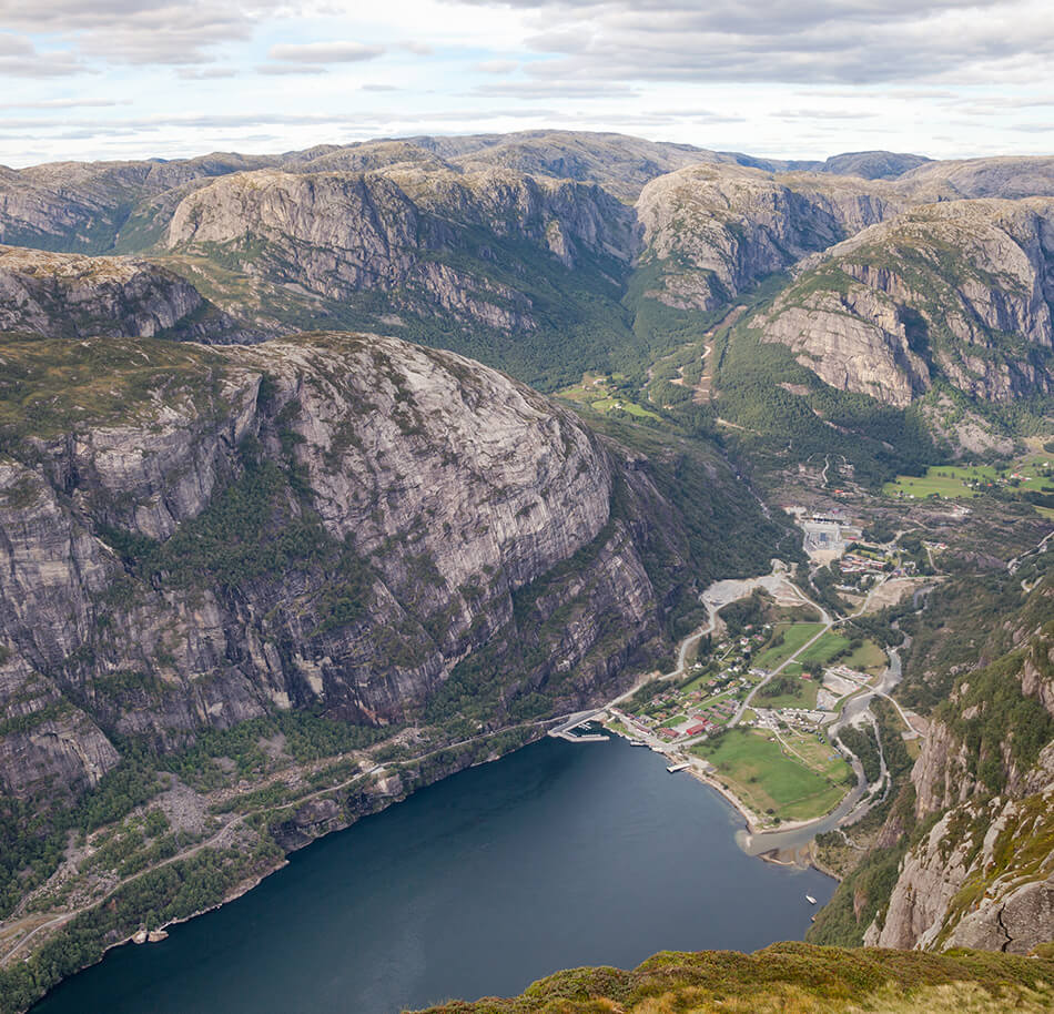
Approx. 10.000 years ago, massive glaciers formed the Norwegian fjords and mountains, and in this process the Kjerag boulder was wedged into a mountain crevasse at 1.000 metres above sea level. When at the boulder you have the most amazing views over the 42 km long Lysefjorden.
Towering 1,100 meters above sea-level, Mount Kjerag is the highest peak along the Lysefjord. Due to its sheer, almost 1,000 meters high cliffs looming over the fjord, the mountainous area is often referred to as the Kjerag Massif.
Kjerag Trail Information
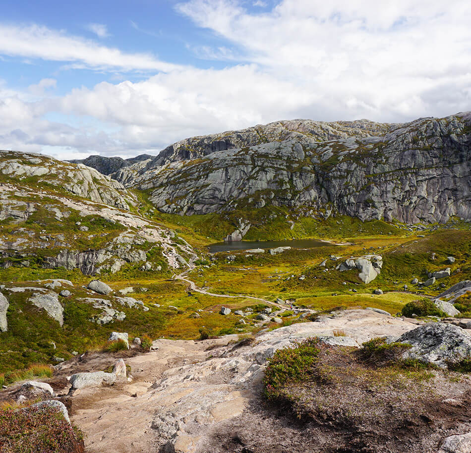
The trail to Kjerag’s Boulder makes up a demanding 11-kilometer hike, which takes 5-6 hours in total (roundtrip). The trail, which includes significant changes in terrain, includes three steep hills separated by shallow valleys. Total elevation gain: 750 meters.

Distance - Round trip
11 km
Total elevation gain
750 meters
total time - Round trip
5-6 hours
Local weather
Open in new window
Kjerag Trail Map


Kjerag Height Profile

Kjerag Trail Video


Parking fee
Free
Free
less than 2 hours - 40 NOK
more than 2 hours - 300 NOK

No camping at/around Kjerag Parking
Getting to Kjerag by car
You can reach the Kjerag trailhead by driving the mountain pass from Sirdal Valley to Lysebotn. From Stavanger, driving around the mountains is the fastest/easiest. You can also take the car on a ferry to Lysebotn, from Lauvvik, Forsand and Songesand. A ferry ride through the Lysefjord can be a welcome break from driving and will be an unforgettable experience.
The ferries have limited capacity and departures and must be pre-booked. More info here.
Driving from the East / Setesdal, the shortest and most scenic route is driving Suleskard mountain pass.
All roads to the trailhead are closed from November to mid-May, due to ice and snow conditions.
Getting to Kjerag by ferry
Lysebotn is the closest ferry quay for hiking Kjerag. It takes time to travel by ferry and hike Kjerag, so we recommend to stay the night in Lysebotn before/after your hike.
The year-round local speedboat calls at the quays in the Lysefjord – Lauvvik, Forsand, Bratteli, Bakken, Songesand, Flørli, Håheller and Lysebotn. Tickets must be booked in advance. More info here.
When arriving as a passenger, you can take the local shuttle bus from Lysebotn to Kjerag Trailhead / Øygardstøl.
Getting to Kjerag by bus
From Stavanger, you can take the Kjerag express bus straight to Kjerag Trailhead / Øygardstøl.
There is a local shuttle bus operating between Lysebotn and Kjerag Trailhead / Øygardstøl.

The famous boulder
Traditionally, locals and tourists admired Kjerag from aboard a ferry. Nowadays, Kjerag is mostly known for its famous boulder, wedged into a mountain crevasse, 984 meters above the fjord. Every year, about 70,000 hikers make their way up the trail to the plateau above the cliffs. For many visitors, having their picture taken while standing on the boulder is the climax of their hike. Kjerag has also become one of the best locations in the world for BASE jumping.
Lysefjorden Rundt
The Kjerag trail is part of the Lysefjorden Rundt Trail: one of the most spectacular multi-day hikes in Norway. The trail is 100 kilometers long and divided in 8 stages. The classic hikes of Kjerag, Preikestolen and Flørli are world-renowned hiking icons, and all located along the Lysefjorden Rundt Trail. Click on the logo below for more information.

Visit Lysebotn & Kjerag
Lysebotn, a charming village nestled at the base of towering cliffs, is your starting point for the exhilarating Kjerag hike, where you’ll stand atop the famous Kjeragbolten, a suspended boulder wedged between two cliffs, offering an adrenaline-pumping adventure and awe-inspiring views of the Lysefjord.
KJERAG
When to go
The road to the Kjerag trail head is open from late May throughout October. The parking lot facilities and tourist information office are open from late May to mid-October.
Safety
The trail to Kjerag is well facilitated and marked and should be easy to find and follow. However, there is always a risk of accident or sudden illness. Mountain rescue and emergency services are on standby.
In case of an emergency – dial 113
“Allemannsretten”
The Norwegian ‘allemannsretten’ (pronounced ALL-eh-mahns-ret-en) gives people the freedom to roam in nature, regardless of whether the land is publicly or privately owned. In Norway, and at Kjerag, you hike at your own risk. The allemannsretten also assumes hikers behave responsible, taking other hikers´ and nature´s wellbeing into account.
Preparations
The trailhead at Øygardstøl is located on the southern side of the Lysefjord, 7.5 kilometers from Lysebotn. Kjerag is a demanding hike. You must be fit, healthy and up for the challenge.
Remember to eat a proper breakfast before the hike to ensure you’ll have energy throughout the day. Make sure you bring a backpack with a packed lunch, extra snacks and plenty of water
Equipment
When hiking in the Norwegian mountains you need to be prepared. Be a pro and bring the right equipment. Your safety, wellbeing and a great experience depend on it. In the video, you can see what type of clothes and equipment we recommend using throughout the year.
Garbage facilities
There are garbage bins at the parking lot/trailhead only – there are no garbage bins along the trail.
We believe all hikers are nature lovers, who do not like to see garbage in nature. Please respect the common ‘leave no trace’ practice. Take nothing but pictures and leave nothing but footprints. If you can take something with you up the mountain, you can also take it back down.
Do not take disposable barbeques to Kjerag. It is our experience that many people do not take them home because they are hot. Smoke can be inconvenient for other hikers, and during periods of drought barbeques may pose a fire hazard.
Toilets
There are toilet facilities at the parking lot/trailhead only – there are no toilets along the trail.
Be prepared to be out in nature 6 to 7 hours, without having access to a toilet. Make sure you have visited the toilets at the parking lot before starting your hike. During peak-days, there can be a few thousand people on the trail. It is our desire that all visitors will have a pleasant hike, without having an impact on nature. Therefore, if at all possible, we kindly ask you not to relieve yourself in nature. If you really must, please do not leave any toilet paper or other sanitary products behind.
Parking
The parking lot is run by Lysefjorden Utvikling and has a capacity of 400 cars. Upon arrival, you will be met by parking attendants. To ensure a smooth parking experience and avoid unsafe traffic situations, please cooperate with the crew and follow their instructions.
The parking fee is 300 Norwegian kroner per car. 100% of the parking fee revenue is used to finance daily operations and reinvest in infrastructure. This includes staff salaries, security and rescue measures, cleaning, maintenance and improvement of the parking and toilet facilities, the trail and signposting, and much more.
Hiking with kids
Kjerag is a demanding hike, part of the trail goes alongside high cliffs. Here, it is very important to take good care if you bring children. It is not recommended to take smaller children to Kjerag. Several sections of the trail are very exposed and/or steep. Using child carriers is therefore not recommended.


Kjerag
Based on our experience, we would like to share some recommendations with you
Flørli
Several hiking trails start in Flørli, some of which are connected to the Lysefjorden Rundt Trail
Preikestolen
Information tools to plan for a safe and enjoyable hike to Preikestolen, whatever season.
Lysefjord visitor guide
As you experience this majestic landscape, remember that your actions hold the power to protect and celebrate our unique destination for all who follow in your footsteps.

Respect Nature

Be Part of the Local Community

Stay Safe
